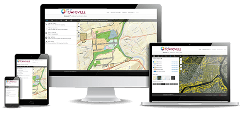
Interactive Zoning Map
a visual zoning solution to Streamline
Your Development Process

Not Just Another Interactive Zoning Map
MapLink
GIS
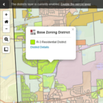
Provides basic parcel data
Displays zoning maps
Identifies parcel zoning districts
Links to online zoning code for full code content
Zoning overlays, basemaps,
custom transparencies, measurement tools
Integrated code content updates
Details parcel level curated zoning essentials
Features “Search By Use” option
Zoning information filtering tools
Shareable parcel level zoning summaries
Intuitive interface regardless of experience level
Permitting and forms
Not Just Another Interactive Zoning Map
MapLink
GIS
Provides basic parcel data
Displays zoning maps
Identifies parcel zoning districts
Links to online zoning code for full code content
Zoning overlays, basemaps, custom transparencies, measurement tools
Integrated code content updates
Details parcel level curated zoning essentials
Features “Search By Use” option
Zoning information filtering tools
Shareable parcel level zoning summaries
Intuitive interface regardless of experience level
Permitting and forms
Over 1.5 Million Citizens Already Benefit From the Convenience of MapLink
Find out how this innovative interactive zoning map solution can help your municipality.
Additional Resources


See MapLink
in Action
Industry Partners Delivering for MapLink

MapLink is now part of ICC Innovation, a new initiative bringing together powerful digital solutions for professional development, community growth, and code compliance.